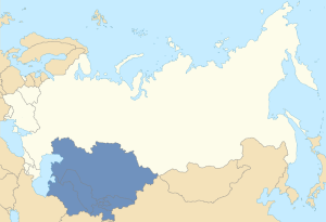
Location of Central Asia in the former Soviet Union
One of the most interesting parts the former Soviet space is Central Asia. It is a region of diverse geography and beautiful people, with a lot of fascinating history behind it. In the West, the five countries of the area have become colloquially known as the “stans” because all of them bear the Persian suffix “-stan” meaning “land of.” The majority of the ethnic groups who live in this region are Sunni Muslims, with the exception of the Orthodox Christian Russians, the Ismaili Pamiris, and other smaller groups. The majority of the titular nationalities also speak Turkic languages, the only exception being Farsi-speaking Tajikistan.
In the Russian language, the term “Средняя Азия” (Srednyaya Aziya), literally “Middle Asia,” is used to denote the former Soviet Central Asian republics. By contrast, the term “Центральная Азия” (Tsentralnaya Aziya), or “Central Asia,” denotes a much broader geographic region, encompassing not only the former Soviet Central Asian states, but also Mongolia, Tibet, Xinjiang, Afghanistan, portions of southern Siberia, and other areas.
Post-Soviet Central Asia was gradually absorbed into the Russian Empire in the 18th and 19th centuries. Russia’s expansion into the area prompted concern from the British, who governed India further south. The result was what Rudyard Kipling called the “Great Game,” as the two great powers vied for influence in the region. The sporting geopolitical competition ended in 1907 with the Anglo-Russian Entente. In the end, much of the region went to Russia and later its successor, the Soviet Union. The Soviet government set to work on establishing ethno-national entities in the region, which eventually became full-fledged union republics. Following the breakup of the Soviet Union in 1991, these countries became fully independent states. Below are concise overviews of each:
Countries:

Location of Kazakhstan in post-Soviet Central Asia
Kazakhstan
Capital: Astana
Official language(s): Kazakh, Russian
President: Nursultan Nazarbayev
Area: 2,724,900 км²
Population: 17,948,816 (CIA 2014 est.)
GDP per capita: $14,100 (CIA 2013 est.)
Geography: Steppe, grassland, arid desert, mountains
Ethnic groups (2009 census): Kazakhs (63%), Russians (23%), Uzbeks (3%), Ukrainians (2%), Uygurs (1%), Tatars (1%), Germans (1%), Others (6%)
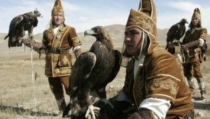
Eagle hunters in Kazakhstan (Getty)
Overview:
Kazakhstan is the largest of all the ex-Soviet Central Asian countries. It is the homeland of the Kazakhs (not to be confused with the similar-sounding Slavic Cossacks) who are a nomadic Turkic-speaking people with strong Mongol cultural influences. Falconry, especially eagle falconry, and horsemanship are very popular among the Kazakhs. The Kazakhs are divided among three historical hordes: the Great Horde in the Southeast, the Middle Horde in the Center and North, and the Lesser Horde in the West.

The “Gagarin’s Start” Soyuz launch pad at the Baikonur Cosmodrome. It was from here where the famous cosmonaut Yuri Gagarin (after whom the launch pad is named) launched into space on Vostok 1 in 1961. (NASA / Bill Ingalls)
In addition to the Kazakhs, there are also many ethnic minorities in Kazakhstan, including a very large ethnic Russian minority concentrated in the North. The sizable Russian community has a historic presence in Kazakhstan, dating back to the Tsarist era. The community grew in the Soviet era, especially in the 1960s during Nikita Khrushchev’s Virgin Lands Campaign. Ethnic relations have been peaceful between the Kazakhs and the large Russian minority. Likewise, relations between the governments of Kazakhstan and Russia are also very amicable. The great Baikonur Cosmodrome from which the famous Sputnik and Vostok operations were launched, is located on the territory of Kazakhstan. However, it is still controlled by Russia per a treaty between Moscow and Astana.

Viktor Tsoi
Kazakhstan’s ethnic mosaic also consists of a variety of other minorities such as Uzbeks, Uygurs, Ukrainians, Poles, Germans, Chechens, Ingush, Koreans, Crimean Tatars, and others. Many of these have a long history in Kazakhstan. Others arrived during the Stalin era as part of a series of forced population transfers.
Notably, the late glasnost-era Soviet rock musician, Viktor Tsoi, was partially descended from Kazakhstan’s significant Korean community. The film, The Needle (Игла), which starred Tsoi, was produced in Kazakhstan and directed by the New Wave Kazakh filmmaker, Rashid Nugmanov.
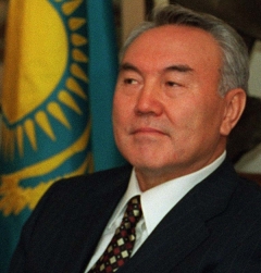
Kazakh President Nursultan Nazarbayev in 1997 (Robert D. Ward)
Kazakh President Nursultan Nazarbayev has been in power since Mikhail Gorbachev appointed him to lead then-Soviet Kazakhstan in 1989. Though he essentially runs the country as a one-man dictatorship where corruption remains a major problem, he nonetheless enjoys popular support for keeping stability, a balanced relationship with Moscow, and for tirelessly promoting Kazakhstan on the international stage. Nazarbayev has also been a vocal proponent for integration among the ex-Soviet states. He has likewise succeeded in attracting foreign investment to Kazakhstan for its vast natural resources, including oil, natural gas, uranium, manganese, copper, and more. In 1997, he moved Kazakhstan’s capital from Alma-Ata (Almaty) to Astana in a more north-central location of the country.
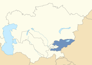
Location of Kyrgyzstan in post-Soviet Central Asia
Kyrgyzstan
Capital: Bishkek
Official language(s): Kyrgyz, Russian
President: Almazbek Atambayev
Area: 199,951 км²
Population: 5,604,212 (2014 CIA est.)
GDP per capita: $2,500 (2013 CIA est.)
Geography: Mountains, fertile valleys
Ethnic groups (2014 census): Kyrgyz (73%), Uzbeks (14%), Russians (6%), Others (7%)

Kyrgyz writer Chinghiz Aitmatov
Overview:
Kyrgyzstan (also known as Kirghizia) is a small and mountainous country located south of Kazakhstan and just west of China. The Kyrgyz are a Turkic-speaking people who, like the Kazakhs, have a nomadic tradition and share many cultural influences from the Mongols. The Tian Shan mountain range runs through much of the country’s west near the much-celebrated Issyk Kul lake. Issyk Kul was a famous resort in Soviet times and also the setting for the Issyk Kul Forum. Founded by the Soviet Kyrgyz writer Chinghiz Aitmatov during glasnost, the Forum was a way of bringing intellectuals from the East and West together. Aitmatov, who passed away in 2008, was a friend and advisor of Mikhail Gorbachev. The Kyrgyz author is still widely respected throughout the former Soviet Union and his stories are still cherished by many in the region to this day.

Kyrgyz yurt (nomadic dwelling) near Issyk Kul
Though not as rich as its northern neighbor Kazakhstan, Kyrgyzstan has distinguished itself as the most democratic country in post-Soviet Central Asia. The current President Almazbek Atambayev claims that this derives from a democratic tradition among the Kyrgyz nomads and thus has labeled his country a “nomadic democracy.” Despite this, Kyrgyzstan is no stranger to unrest. Since the end of the Soviet era, this small country has experienced two political revolutions, one in 2005 and another in 2010. It has also seen ethnic unrest between the dominant Kyrgyz and the significant Uzbek minority in the southern city of Osh in the Fergana Valley. Clashes occurred in both 1990 and most recently in 2010. Kyrgyzstan is still recovering from the more recent ethnic riots.
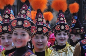
Kyrgyz women in traditional costume (AFP)
After September 11, the US opened the Manas Air Base in Kyrgyzstan. Russia’s Vladimir Putin initially approved of this move and allowed the US to operate this base in former Soviet territory as part of its war against the Taliban in Afghanistan. However, as US-Russian relations became strained, Putin decided to pull the plug on the Manas base and sought to have Bishkek close it. After his election in 2011, Kyrgyz President Atambayev announced that he would seek the closure of the base when its lease expires. In June 2014, the US vacated the base.
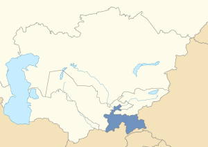
Location of Tajikistan in post-Soviet Central Asia
Tajikistan
Capital: Dushanbe
Official language(s): Tajik
President: Emomali Rahmon
Area: 143,100 км²
Population: 8,051,512 (2014 CIA est.)
GDP per capita: $2,300 (2013 CIA est.)
Geography: Mountains, fertile valleys
Ethnic groups (2010 census): Tajiks (84% including Pamiris), Uzbeks (14%), Others (2%)

Tajik woman in national dress
Overview:
Geographically, Tajikistan is the smallest of the ex-Soviet Central Asian states. It is also the most mountainous. The Pamir Mountains cover most of the eastern part of the country in the Gorno-Badakhshan Autonomous Oblast. The Tajiks are basically a subgroup of ethnic Persians. Their native language, Tajik, is a dialect of Farsi, distinguishing them from their Turkic-speaking neighbors.
The Tajiks live not only in Tajikistan but also in significant numbers in neighboring Uzbekistan and to the south in northern Afghanistan. Ahmad Shah Massoud, the famed leader of Afghanistan’s Northern Alliance was an ethnic Tajik. In addition, Tajikistan is also home to the Pamiri people who are natives of Gorno-Badakhshan.

Spetsnaz troops in the Tajikistan Civil War (Ussuriysk Military School /
Dmitry Ivlyov)
Tajikistan is the poorest ex-Soviet state in Central Asia and it has a history of instability going back to the time of the Soviet collapse. After independence, the country plunged into a violent civil war. The civil war had its origins in the unequal power distribution among the country’s regions. The government was dominated by people from the Leninabad (today Khujand) region in the north and the republic’s security forces were dominated by people from Kulyab in the south. The people from the central Garm region and the eastern Gorno-Badakhshan Autonomous Oblast, inspired by Gorbachev’s glasnost, demanded more of a say in the government. Their political coalition was an ideological hodge-podge mix of liberal democrats, nationalists, and Islamists. Ultimately, the government refused to share power and it was this that led to the civil war between the sides.
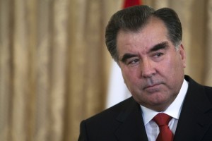
Tajik President Emomali Rahmon (Getty / Majid Saeedi)
The conflict in Tajikistan lasted until 1997 when a power-sharing peace deal was finally agreed upon with the help of negotiation by Moscow. Since then, the country has been relatively stable. Emomali Rahmon, the country’s longtime strongman, has remained in power since the 1990s. The drug trade, which runs from neighboring Afghanistan, seeks to use Tajikistan as a major transit route to the former Soviet states and Europe, posing a serious challenge for the government.
Recently, Tajikistan has sought to enrich itself by capitalizing on its major glacier and water resources. Water resources are highly valued in a region like Central Asia which includes large arid desert areas. Tajik interest in using their water resources for hydroelectric energy has created tension with drier neighbor Uzbekistan. Tashkent is fearful that such projects could adversely affect its water supply and, by extension, its cotton production.
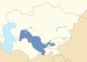
Location of Uzbekistan in post-Soviet Central Asia
Uzbekistan
Capital: Tashkent
Official language(s): Uzbek
President: Islam Karimov
Area: 447,400 км²
Population: 28,929,716 (2014 CIA est.)
GDP per capita: $3,800 (2013 CIA est.)
Geography: Arid desert, fertile valleys, mountains
Ethnic groups (2000 estimate): Uzbeks (78%), Russians (5%), Tajiks (5%), Kazakhs (4%), Karakalpaks (2%), Others (6%)
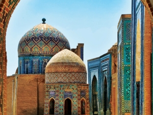
Samarkand (Malika Hotels)
Overview:
Uzbekistan is the most populous country in Central Asia. Uzbeks, a Turkic-speaking people, are the dominant population of Uzbekistan. Their ethnonym “uzbek” literally translates as “his own lord,” meaning a “free” or “independent” person. The country also includes many ethnic minorities including Russians, Tajiks, Kazakhs, and Karakalpaks. The capital Tashkent was founded in the 8th century as an oasis on the Silk Road. Uzbekistan is also home to great Islamic cultural centers such as Bukhara, Samarkand, and the historic Khwarezm capital of Khiva, all boasting visually stunning art and architecture. Many Tajiks live in Samarakand and Bukhara and some Tajik nationalists have even claimed these cities for Tajikistan. However, the beauty of these great centers go beyond any ethnic or national divisions and are treasured by all Central Asians as part of their collective cultural heritage.
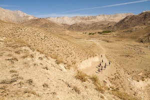
The Kyzyl Kum (VisitUzbekistan)
Uzbekistan’s landscape is diverse. Much of the country’s west is covered by the hot Kyzyl Kum (“Red Sands”) desert. The large Aral Sea used to be a major feature of western Uzbekistan. However, due to Soviet-era irrigation schemes involving the Amu Darya and Syr Darya rivers and the Karimov government’s inaction, the once-great sea has now shrunk to near-nonexistence. The eastern part of Uzbekistan, centered on the Fergana Valley is more fertile, though this part of Central Asia has also been known for ethnic tension, disputed borders, and Islamic extremism. The country also has a wealth of natural resources including natural gas, oil, and gold and is renown for its cotton growth.

Uzbek Leader Islam Karimov (RIA Novosti / Sergey Guneev)
Of all the post-Soviet Central Asian states, Uzbekistan is the most repressive. The president, Islam Karimov, was elected to lead the country in 1990 and has remained in this position, establishing himself as an authoritarian despot. Rampantly corrupt, Karimov’s regime is particularly notorious for its use of medieval-style torture. Though potential Islamic extremism is a serious concern for Uzbekistan, the government has used this liberally as an excuse to crackdown on any dissent in the country. As a police state, it keeps a watchful eye on all of its citizens. In 2005, a popular uprising against the regime in the eastern city of Andijan was put down brutally, with the Uzbek government forces cruelly firing into a crowd of men, women, and children. Estimates of those killed range from 400 to more than 1,000.

Gulnara Karimova (Getty)
In recent years, Karimov’s daughter, Gulnara, has also been in the news. An oligarch with a taste for fashion and pop-singing, she is regarded as a very controversial figure. She lost her influence in Uzbekistan after she criticized her father’s repressive regime. Since then, her father has attempted to silence her, but she has continued her criticism of his policies regardless. She was recently arrested.
After the 9/11 attacks, Russian President Vladimir Putin allowed the US to use Uzbekistan’s Karshi-Khanabad Air Base for its operations in Afghanistan. However, after the US criticized Karimov’s crackdown at Andijan, Tashkent told Washington to vacate the base. Russia, whose relations were already souring with the US at this time, approved of the evacuation of the base. However, relations between Moscow and Tashkent have also been uneasy. In 2012, Uzbekistan withdrew from the Moscow-backed CSTO military alliance.
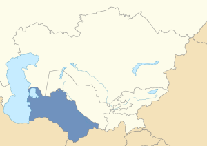
Location of Turkmenistan in post-Soviet Central Asia
Turkmenistan
Capital: Ashgabat
Official language(s): Turkmen
President: Gurbanguly Berdymuhamedov
Area: 491,210 км²
Population: 5,171,943 (2014 CIA est.)
GDP per capita: $9,700 (2013 CIA est.)
Geography: Arid desert
Ethnic groups (2010 estimate): Turkmen (79%), Uzbeks (9%), Russians (3%), Kazakhs (3%), Others (6%)
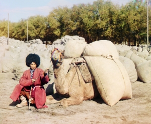
Turkmen man with camel, early 20th century (Sergey Prokudin-Gorsky)
Overview:
Turkmenistan (also known as Turkmenia) is the homeland of the Turkmen, a traditionally nomadic Turkic-speaking people. The country borders Iran to the southwest and Afghanistan to the southeast. About 70% of its territory is covered by the inhospitable Karakum (“Black Sands”) Desert and its population is consequently sparse and spread out. Camel herding is a major occupation for many Turkmen and it is not uncommon to see dromedaries lazily walking alongside Turkmenistan’s vast desert highways. Many great powers have passed through far-flung Turkmenistan’s desert landscape over the centuries, particularly the Persians who left behind historical ruined cities like Merv and Nisa.

Darvaza Natural Gas Crater, Turkmenistan (National Geographic / Nick Hannes and Hollandse Hoogte)
On the surface, Turkmenistan appears to be a desolate country with little to offer. Yet appearances can be deceiving. Underneath Turkmenistan’s barren land are rich deposits of oil and especially natural gas. In fact, Turkmenistan has the fourth largest reserves of natural gas in the world. This has attracted a lot of interest, from the traditional power of Russia to new players in the region, such as the US and China. Perhaps the best illustration of the scale of Turkmenistan’s reserves is the fiery Darvaza natural gas crater (also known as the “Doorway to Hell”) located in the middle of the Karakum. In 1971, Soviet engineers began to drill for natural gas in this area. However, the ground beneath the drilling rig sank below grade, creating a large pit. The Soviets decided to burn the pit, fearful of the release of poisonous gases. It was initially believed that the gas would burn out in a matter of weeks. However, it has persisted for nearly 43 years. The first human expedition of the fiery pit was made by explorer George Kourounis in November 2013.
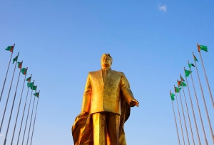
Saparmurat Niyazov gold statue in Ashgabat (Robert Preston)
One of the more unusual phenomena to emerge from Turkmenistan since the Soviet collapse has been its late President Saparmurat Niyazov. Niyazov was an authoritarian leader who was just as eccentric as he was autocratic. Channeling Turkey’s Atatürk, he Latinized the previously Cyrillic-based Turkmen alphabet and styled himself “Turkmenbashi,” meaning “Leader of the Turkmen.” He established an all-pervasive personality cult and even erected a gold statue to himself in the capital Ashgabat. Niyazov also issued bizarre decrees such as banning ballet, opera, makeup, and lip-syncing, and named months after his own family members. In addition, he authored a book known as the Ruhnama, a text comparable to Mao’s Little Red Book or Muammar Gaddafi’s Green Book, containing a mix of spiritual guidance, pseudo-history, autobiography, and poetic verse. The book was made mandatory in all Turkmen schools and a monument to it was even built in Ashgabat. Following Niyazov’s death in 2006, his successor Gurbanguly Berdymuhamedov reversed many of his absurd decrees and removed his personality cult. However, Berdymuhamedov too appears to prefer ruling as an all-powerful authoritarian leader as opposed to introducing any sort of competitive democracy to Turkmenistan.
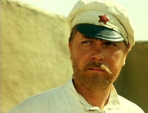
Anatoly Kuznetsov as Comrade Sukhov in White Sun of the Desert (1970).
In the post-Soviet world Turkmenistan is also widely renown as the setting for the much celebrated 1970 Soviet film White Sun of the Desert (Белое солнце пустыни). This film, which featured the famous song Your Honor Lady Luck (Ваше благородие, госпожа Удача) by the bard Bulat Okudzhava, was one of many in the Soviet “Ostern” genre. These “Osterns” (or “Easterns”) very much resembled American Westerners, except they were set in the deserts of Soviet Central Asia as opposed to the American southwest. Directed by Vladimir Motyl, White Sun of the Desert also introduced many common phrases into the Russian language including “Восток — дело тонкое” (“The East — a delicate matter”), “Вопросы есть? Вопросов нет!” (“Are there any questions? Of course not!”), “Таможня дает добро!” (“Customs gives the green light!”), and “Гюльчатай, открой личико!” (“Gyulchatai, show your face!”).
Autonomous regions:

Location of the Gorno-Badakhshan Autonomous Oblast within Tajikistan in post-Soviet Central Asia
Gorno-Badakhshan Autonomous Oblast, Tajikistan
Capital: Khorog
Official language(s): Tajik (Pamiri languages widely spoken)
Governor: Shodikhon Jamshedov
Area: 64,200 км²
Population: 218,000 (2008 est.)
Geography: Mountainous
Ethnic groups: Pamiris, Kyrgyz
Overview:
The Gorno-Badakhshan Autonomous Oblast is perhaps the highest region in the former Soviet Union. It is almost completely covered by the Pamir mountains which, along with the nearby Himalayas, have been dubbed the “Roof of the World.” The tallest mountain peak of the former Russian Empire and the former USSR, Peak Kommunism (now Ismoil Somoni Peak) is located in Gorno-Badakhshan.

Pamiri children in Barchadev, Gorno-Badakhshan Autonomous Oblast, Tajikistan (Robert Middleton)
The population of the oblast is primarily comprised of ethnic Pamiris, an Iranic people distinct from the Tajiks who speak the Pamiri languages, not Farsi. Unlike the mostly Sunni Tajiks, the Pamiris are Ismaili Muslims (an off-shoot of Shiism). In addition to their homeland in Gorno-Badakhshan, the Pamiris also live in Afghanistan’s northernmost province of Badakhshan and in the westernmost portions of China’s Xinjiang Uyghur Autonomous Region (particularly in the Tashkurgan Tajik Autonomous County). They are closely related to the Wakhi speakers of Afghanistan’s Wakhan corridor and Pakistan’s far-northern Gilgit-Baltistan territory (part of disputed Kashmir).
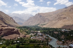
Khorog, capital of the Gorno-Badakhshan Autonomous Oblast (Bakhriddin Isamutdinov)
The region was the last part of post-Soviet Central Asia to become part of the Russian Empire in 1895. It was also the last territory acquired by the Russian Empire before the Revolution of 1917. [CORRECTION (11 Sept. 2016): The last territory acquired by the Russian Empire was actually the Severnaya Zemlya archipelago in the high Arctic in 1913. Other northern islands were also claimed by the Russian Empire prior to 1917, including Franz Josef Land, Victoria Island, and Wrangel Island. However, all of these islands would only be formally annexed to Russia in 1926 by the Soviet government.]
The boundary was drawn dividing the historic Badakhshan region between the Russian and British Empires (the latter of which controlled the foreign affairs of Afghanistan). The Chinese Qing dynasty also had claim over the region. It was not until 2002 that the People’s Republic of China finalized its frontiers with then post-Soviet Tajikistan. However, the Republic of China, exiled in Taiwan, refuses to recognize this and continues to claim Gorno-Badakhshan as part of mainland China.
During the 1990s civil war in Tajikistan, the Pamiris of Gorno-Badakhshan sided with the Garmis in demanding more equal power from the government. Many people from Garm and Gorno-Badakhshan had been relocated to the country’s south and western cotton-growing areas during the Soviet era. During the early part of the war, many of the Garmis and Pamiris in this part of the country faced attacks and expulsions from government forces in what Human Rights Watch dubbed an “ethnic cleansing campaign.” Many fled back to their traditional native regions in Tajikistan, while others fled across the border into Afghanistan. The result was a radicalization of the sides and an intensification of the conflict.
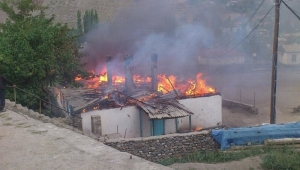
Clashes in Gorno-Badakhshan, 2012 (Reuters)
The civil war continued in Tajikistan until a power-sharing a agreement was brokered with Russian assistance in 1997. Since then, Gorno-Badakhshan has remained relatively peaceful. However, in 2012, clashes erupted in the region between loyalists of the warlord Tolib Ayombekov and the Tajik military. Moscow observed the situation with concern. After intense fighting on July 24, Tajik leader Emomali Rahmon called for a ceasefire. Peace and stability have since been restored to the area.
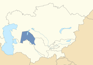
Location of the Karakalpakstan within Uzbekistan in post-Soviet Central Asia
Karakalpakstan Autonomous Republic, Uzbekistan
Capital: Nukus
Official language(s): Karakalpak, Uzbek
Governor: Musa Erniyazov
Area: 164,900 км²
Population: 1,711,800 (2013 est.)
Geography: Arid desert
Ethnic groups (2007 estimate): Karakalpaks (33%), Uzbeks (33%), Kazakhs (25%), Others (9%)
Overview:
Karakalpakstan is an autonomous region that encompasses much of western Uzbekistan. Linguistically and culturally, the Karakalpaks closely resemble the Kazakhs more than the Uzbeks. It is noteworthy that the area was once an autonomous region within Soviet Kazakhstan during the NEP era of the 1920s, before its jurisdiction was transferred to the Russian SFSR in 1930 and eventually to Soviet Uzbekistan in 1936. The name “Karakalpak” roughly translates as “black hat,” but the origin of this name is obscure. There are theories linking the Karakalpaks to the Chorni Klobuky (“black hat”) mercenaries of the Kievan Rus’ from the 11th and 12th centuries, though aside from the common meaning of their names, there is no evidence linking these two groups. The Karakalpak homeland is arid and almost completely covered by desert.
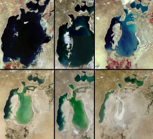
Photographs illustrating the diminution of the Aral Sea. From left to right: (top row) 1973, 1989, 1999, (bottom row) 2001, 2003, 2009 (US Geological Survey and NASA)
Karakalpakstan was once a prosperous region in Soviet times. However, in the post-Soviet era, the region has fared badly within independent Uzbekistan. It has become the country’s poorest region and has suffered the greatest from the rapidly diminishing and now disappearing Aral Sea, which used to be a major feature of the region. The area is now experiencing a severe drought. Temperatures have increased. Sea salt and other chemicals from the dried bed of the salient sea have become wind-borne, poisoning the local environment and creating serious respiratory problems for the people living in the area. Meanwhile, the sea continues to shrink and Tashkent has done nothing to prevent what many regard as an environmental catastrophe. There are rumblings by some Karakalpak activists about possible independence from Uzbekistan, though Tashkent has been quick to deny this.
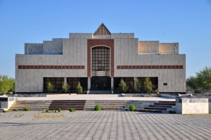
Nukus Art Museum (Panoramio)
The ancient oasis region of Khwarezm encompassed a significant portion of modern Karakalpakstan, particularly in the Amu Darya river delta. As such, the area has inherited many historic ruins and archeological sites of interest. Additionally, the capital Nukus is also the home of the famed Nukus Art Museum, or more formally the State Art Museum of the Republic of Karakalpakstan, after I. V. Savitsky. The museum houses the second largest collection of Russian avant-garde art in the world after the Russian Museum in St. Petersburg. Igor Savitsky, the museum’s founder, collected them at great risk of his own life, especially during Stalin’s era. In 2010, the museum was prominently featured in the documentary, The Desert of Forbidden Art with narration by Ben Kingsley and others.


